
Geography 2005 Jamb Examination
Geography 2005 Jamb Examination

Question 31
The raw material for terylene is?
Terylene is a synthetic polyester fibre produced through the polymerisation of organic compounds derived from petrochemicals.
Petroleum provides the necessary hydrocarbons used to manufacture ethylene glycol and terephthalic acid, the two key components required to form terylene.
Natural materials such as wool or cotton cannot be used for this process because they do not contain the specific chemical components needed for polyester production.
Petroleum provides the necessary hydrocarbons used to manufacture ethylene glycol and terephthalic acid, the two key components required to form terylene.
Natural materials such as wool or cotton cannot be used for this process because they do not contain the specific chemical components needed for polyester production.
Not clear enough?
Question 32
The most important effect of migration on population is?
Migration directly influences the spatial arrangement of people within a geographic area.
When individuals move from one location to another, some regions experience population gains while others experience losses.
This movement results in a redistribution of population, which is the most significant demographic effect because it alters population structure, density, and settlement patterns.
When individuals move from one location to another, some regions experience population gains while others experience losses.
This movement results in a redistribution of population, which is the most significant demographic effect because it alters population structure, density, and settlement patterns.
Not clear enough?
Question 33
The Ruhr coalfield is located in?
The Ruhr coalfield is a major industrial region in Western Europe and is internationally recognised as one of the largest coal and steel-producing centres.
It is situated in western Germany, forming the nucleus of the country's heavy industrial development.
Other listed countries do not contain the Ruhr region.
It is situated in western Germany, forming the nucleus of the country's heavy industrial development.
Other listed countries do not contain the Ruhr region.
Not clear enough?
Question 34
British foreign investments are concentrated in?
A significant proportion of British foreign investments traditionally flows into developed economies with strong financial systems and stable markets.
These countries offer lower risks, predictable returns, and well-structured business environments, making them favourable destinations for large-scale investment.
While the Commonwealth and EU receive investment, developed countries as a category capture the largest share.
These countries offer lower risks, predictable returns, and well-structured business environments, making them favourable destinations for large-scale investment.
While the Commonwealth and EU receive investment, developed countries as a category capture the largest share.
Not clear enough?
Question 35
South-facing slopes are favourable for rural settlement locations in the cool temperate regions of the northern hemisphere because they?
In the northern hemisphere, south-facing slopes are oriented towards the sun and therefore receive greater exposure to solar radiation.
This increased warmth helps reduce the effects of cold temperatures, making such slopes more suitable for settlement and small-scale farming.
Other options may be secondary benefits in certain contexts, but the primary geographic reason relates to higher solar energy input.
This increased warmth helps reduce the effects of cold temperatures, making such slopes more suitable for settlement and small-scale farming.
Other options may be secondary benefits in certain contexts, but the primary geographic reason relates to higher solar energy input.
Not clear enough?
Question 36
The data best describes
| J | F | M | A | M | J | J | A | S | O | N | D | |
| Temp.°C | 24 | 24 | 27 | 28 | 30 | 29 | 27 | 27 | 27 | 28 | 27 | 25 |
| 2 | 2 | 0 | 0 | 18 | 505 | 610 | 368 | 269 | 48 | 10 | 0 |
The temperature values remain high throughout the year, staying between 24°C and 30°C, which is characteristic of tropical regions.
The rainfall pattern shows an extremely wet season with peak rainfall exceeding 500 mm, followed by a pronounced dry season with near-zero rainfall around December to March.
This pattern of heavy rains followed by a clear dry season is typical of a tropical monsoon climate, not equatorial climate where rainfall is well distributed throughout the year.
The rainfall pattern shows an extremely wet season with peak rainfall exceeding 500 mm, followed by a pronounced dry season with near-zero rainfall around December to March.
This pattern of heavy rains followed by a clear dry season is typical of a tropical monsoon climate, not equatorial climate where rainfall is well distributed throughout the year.
Not clear enough?
Question 37
The annual range of temperature is
| J | F | M | A | M | J | J | A | S | O | N | D | |
| Temp.°C | 24 | 24 | 27 | 28 | 30 | 29 | 27 | 27 | 27 | 28 | 27 | 25 |
| 2 | 2 | 0 | 0 | 18 | 505 | 610 | 368 | 269 | 48 | 10 | 0 |
Annual range of temperature = highest temperature − lowest temperature.
Highest temperature = 30°C (May).
Lowest temperature = 24°C (January and February).
Therefore, annual range = 30 − 24 = 6°C.
Highest temperature = 30°C (May).
Lowest temperature = 24°C (January and February).
Therefore, annual range = 30 − 24 = 6°C.
Not clear enough?
Question 38
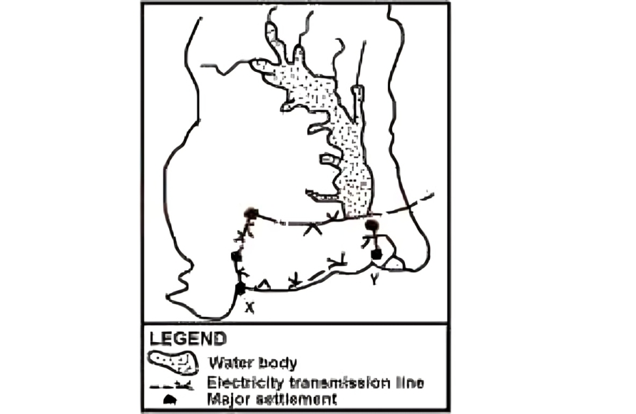
The reservoir was created primarily for
The image represents the Akosombo Dam area in Ghana, where the Volta Lake was created after the construction of the dam.
The primary purpose of this reservoir was the generation of hydroelectric power on an industrial scale, supplying electricity to Ghana and neighbouring regions.
Other functions exist, such as fishing and transportation, but power generation remains the major reason for the reservoir’s creation.
The primary purpose of this reservoir was the generation of hydroelectric power on an industrial scale, supplying electricity to Ghana and neighbouring regions.
Other functions exist, such as fishing and transportation, but power generation remains the major reason for the reservoir’s creation.
Not clear enough?
Question 39
The Town marked X and Y respectively are
On the map, X is located along the southern coastline close to Ghana’s major port city,
Not clear enough?
Question 40
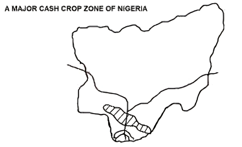
The Major cash crop in the shaded portion is
The shaded region shown on the map corresponds to the forested southern part of Nigeria, well known globally for extensive palm oil production.
The climatic conditions of this region—high rainfall, warm temperature, and rich forest soil—support large-scale cocoa farming more than any other crop listed.
Nigeria is among the world's leading palm oil producers, confirming it as the major cash crop for the highlighted area.
The climatic conditions of this region—high rainfall, warm temperature, and rich forest soil—support large-scale cocoa farming more than any other crop listed.
Nigeria is among the world's leading palm oil producers, confirming it as the major cash crop for the highlighted area.