
Geography 2006 Jamb Examination
Geography 2006 Jamb Examination

Question 1
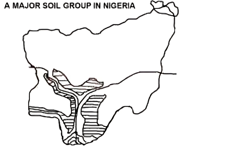
The shaded area is the
The shaded zone represents a structural depression extending along the alignment of the Niger and Benue Rivers. This feature is recognised as the Niger-Benue trough, a major tectonic structure formed by crustal subsidence.
The outline and orientation on the map correspond to this elongated rift-like depression.
The outline and orientation on the map correspond to this elongated rift-like depression.
Not clear enough?
Question 2
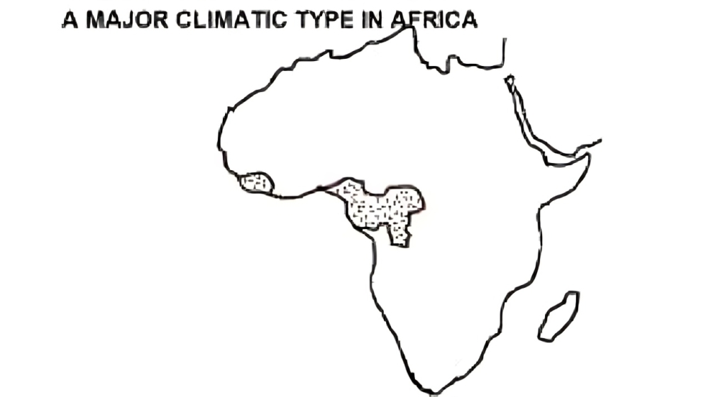
The main annual rainfall in the shaded area is
The shaded region lies within a zone experiencing high rainfall influenced by strong moist tropical air masses. Annual precipitation here typically ranges between 1600 mm and 3200 mm.
“This amount matches the climatic characteristics of Nigeria’s humid rainforest belt.”
“This amount matches the climatic characteristics of Nigeria’s humid rainforest belt.”
Not clear enough?
Question 3
The rains occur mainly as a result of
Rainfall in the shaded region is primarily associated with strong convection caused by intense surface heating and abundant moisture.
“These conditions generate vigorous upward air movement, forming cumulonimbus clouds that bring heavy rains typical of convectional rainfall.”
“These conditions generate vigorous upward air movement, forming cumulonimbus clouds that bring heavy rains typical of convectional rainfall.”
Not clear enough?
Question 4
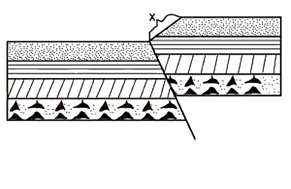
The landform is the result
The diagram shows folded rock layers with uplifted and depressed sections typical of compressional forces. The structure reflects lateral pressure that causes folding without significant tensional separation.
“This identifies compressional faulting as the primary agent shaping the landform.”
“This identifies compressional faulting as the primary agent shaping the landform.”
Not clear enough?
Question 5
The slope identified as X is
The marked slope represents a steep face produced by vertical displacement along a fault plane. This characteristic steep slope is known as a fault scarp.
“It forms where one block is lifted relative to another during compressional or tensional tectonic movement.”
“It forms where one block is lifted relative to another during compressional or tensional tectonic movement.”
Not clear enough?
Question 6
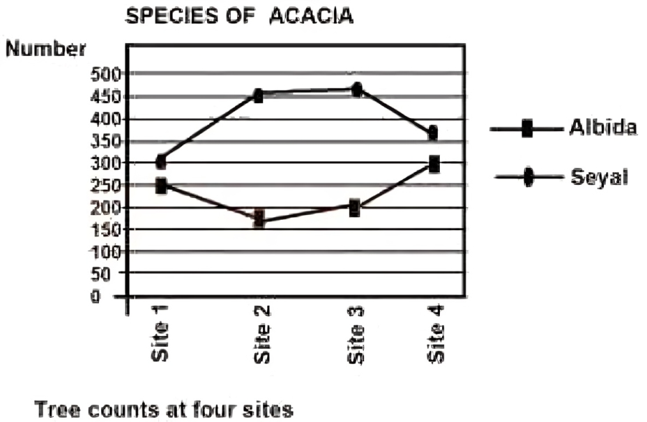
The total number of Acacia albida in the four sites is approximately
Summing the Acacia albida values from all four bars on the graph gives a total close to 930. The graphical heights indicate similar counts across sites, with combined values aligning most closely with 930.
“This makes option C the nearest correct estimate.”
“This makes option C the nearest correct estimate.”
Not clear enough?
Question 7
Which of the following statements about the diagram is true?
Inspection of the bar heights shows that the value for Acacia albida at site 1 matches the value for Acacia seyal at site 4. Both bars rise to the same approximate height, indicating equal populations.
“This makes the first statement the true one.”
“This makes the first statement the true one.”
Not clear enough?
Question 8
The area lies mainly in the
The map shading corresponds to the transitional zone between forest and drier northern grasslands, known as the Guinea savanna. This zone is characterised by woodland vegetation and moderate rainfall.
“The coordinates and shading pattern match this ecological region.”
“The coordinates and shading pattern match this ecological region.”
Not clear enough?
Question 9
The major difference between communication and transportation is that transportation?
Transportation is the physical movement of goods and people from one location to another. Communication, however, deals with the transfer of information without physical carriage.
“This functional distinction is the fundamental difference between the two processes.”
“This functional distinction is the fundamental difference between the two processes.”
Not clear enough?
Question 10
Many important ancient settlements in the Middle East developed as a result of the?
Ancient Middle Eastern civilisations flourished along major caravan and maritime trade routes that connected Asia, Africa and Europe. These routes encouraged settlement growth by facilitating commerce and cultural exchange.
“Oil was not a factor in ancient settlement formation, making trading routes the valid reason.”
“Oil was not a factor in ancient settlement formation, making trading routes the valid reason.”